Park sector · Gatineau Park · ·
La Peche Ridge Link
This is the least known route in the guide and the one that most repays the effort of finding it: 7.2 km of ridge line between two lake basins, with a 1.1 km section along a rock rim above Meech Creek valley that has no equivalent elsewhere in the park. The catch is the access: P18 has ten spaces, the trail is signposted only in French, and the first 900 m follows a hydro right-of-way that is not the route.
Arrival
From P17 continue north 3.4 km on Chemin de la Riviere-aux-Sables to P18. The trail leaves the north-east corner of the lot, crosses a hydro right-of-way for 900 m, then turns north-east into the woods at a blue disc. The right-of-way looks like a trail and is not; it continues to a tower access road that goes nowhere.
The line
0.0-0.9 km · Hydro right-of-way
Straight, wide and apparently obvious - and wrong if you stay on it. The snowshoe route turns off at 900 m. Snow depth on the right-of-way measured only 34 cm because it is fully exposed to the west wind.
0.9-2.9 km · Climb to the ridge
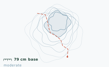
A 200 m climb at 14-16 degrees through a mixed stand, then a broad ridge at 300 m. Snow depth at the 2.2 km stake measured 79 cm on 24 January, more than double what the right-of-way held.
2.9-5.4 km · Rock rim above Meech Creek
The ridge narrows and runs along a rock rim for 1.1 km. There are four open views west into the Meech Creek valley. This is the section that makes the route worth the drive; it is also where the ridge is only 8-12 m wide in three places.
5.4-7.2 km · Descent and return
The ridge drops on a long diagonal to the lake shore, then the route follows the shoreline south for 800 m back to the P18 access track.
Travelling the line, step by step
- Mark the 900 m turn on your map before leaving the lotThe right-of-way is the obvious line and it is the wrong one. Write the turn distance on your hand if you have to.
- Switch to microspikes for the right-of-way and back to snowshoes at the discThe first 900 m is a wind-scoured crust that shreds snowshoe crampons and is faster on spikes. The woods beyond hold 79 cm.
- Walk the east half of the tread on the rim sectionThe west lip is where a cornice forms and where the 40 m drop is. The east half is on solid ground the whole way.
- Take the shoreline for the last 800 m rather than the ridgeThe ridge descent has a long diagonal with a side slope; the shoreline is flat and 400 m shorter, and the two inlets are both bridged by beaver dams.
What to carry
- Snowshoes; the ridge is unpacked and the right-of-way is wind-scoured to a crust
- Microspikes for the 34 cm crusted right-of-way section
- Map and compass; the only sign on this route is one blue disc at 900 m and it is in French
- One pole for the rim section, where the tread is narrow
- Warm layer for the four open rim views, which are fully exposed to the west
- Insulated bottle; the descent to the lake shore is the only sheltered stop
What can go wrong
- IceThe hydro right-of-way is wind-scoured to a hard crust and is the iciest surface on the route.
- AvalancheThe rock rim above Meech Creek is narrow with a 40 m drop on the west side and no barrier.
- Open waterThe lake shore at 6.4 km has two inlets that stay open through mild spells.
The right-of-way turn is the single navigation decision that matters: miss it and you walk 3 km to a locked tower gate. Mark the turn on your map before you start. On the rim section, the ridge is 8 m wide in three places and a cornice can form on the west lip - keep to the east half of the tread. There is no cell coverage on the ridge.
Before you go
- Why is the sign only in French?
- Gatineau Park is administered by the NCC and the La Peche sector signage was replaced in 2019 with French-only plates after a budget cut. The main sectors have bilingual signs; this one does not.
- How do I know I am on the right line at the turn?
- The blue disc sits on a tree 8 m east of the right-of-way edge. If you reach a second set of tower footings, you have passed it.
- Can this be linked to the La Peche lake circuit?
- Yes, by descending to the lake shore and joining the circuit at its 6.9 km point. That combination is 13 km and is a full day.
Nearby and similar
- La Peche Lake Circuit · Gatineau Park · 9.4 km · Easy
- Luskville Ridge Loop · Gatineau Park · 6.8 km · Moderate
- Luskville Falls Ascent · Gatineau Park · 4.2 km · Challenging
The figures above are our own measurements from the date shown. Only the conditions on your day count: check the current forecast, the gate bulletin and the snowpack before you set out, and treat every ice crossing as open until you have tested it.