Forest road sector · Adirondack High Peaks · ·
St. Regis Portage Line
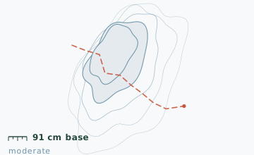
The St. Regis canoe area is a 75 km2 maze of ponds and short carries that nobody visits in winter, which is exactly why it is worth going. The route described here links four ponds with three carries, running north-west to south-east, and it uses the same footpaths that canoeists use in July. Navigation is the challenge rather than terrain: the carries are unmarked in winter and two of them start from points that are invisible from the water.
Arrival
Keese Mill Road from Route 30, 6.8 km west. The road is plowed to the canoe access but not beyond. From the access, the first carry is 200 m north-east along the shore to a put-in on the north-west bay of Upper St. Regis Lake. Every water body on this route should be probed before crossing, and the two narrow channels are the places to be most careful.
The line
0.0-2.4 km · Upper St. Regis Lake
A 2.4 km crossing of the north-west bay on ice, passing two summer camps on the far shore. Ice measured 34 cm on 25 January. Camp property starts at the shoreline; the carry trail is on the marked right-of-way between the two camps and is easy to miss.
2.4-4.8 km · Carry to Bog Pond
A 600 m carry climbing 22 m through spruce, then a 1.8 km crossing of Bog Pond. This pond is shallow and spring-fed, and it is the last water in the chain to freeze - in a mild winter it can still be open in the middle in mid-January.
4.8-7.9 km · Two carries and a narrow channel
Two carries of 300 m and 450 m, separated by a 90 m channel connecting two unnamed ponds. The channel has moving water and should be crossed on the carry trail that runs along its north bank.
7.9-10.6 km · Long return leg
The final leg follows the south-east shore of the last pond and then a 2.2 km forest road back toward Keese Mill Road. The forest road is not plowed and is easy to follow, but it ends 1.4 km from the parking, so you walk the road shoulder for the last stretch.
Travelling the line, step by step
- Probe every water body before you commit to itTen metres out from the shore, chip a hole and read the thickness. Under 15 cm for a loaded group, take the carry trail instead, even if it adds a kilometre.
- Find the right-of-way between the two camps on Upper St. RegisThe carry starts at a gap in the shoreline vegetation 2.4 km from the put-in, marked in summer by a yellow disc. If you reach the second camp dock you have gone 120 m too far.
- Use the north-bank trail around the 90 m channelThe channel between the two unnamed ponds has current. The trail is faint but consistent, staying 8-10 m back from the bank.
- Set a hard turnaround at the second pondIf you are at the second pond after 13:00 in January, go back the way you came. The return along the forest road in the dark is navigable but the road shoulder at the end is not.
What to carry
- Ice chisel and a 30 m throw line if you are leading a group
- Snowshoes for the carries; the ponds can be done in boots if the surface is hard
- Compass and a paper map - there are no signs on the carries and no cell coverage at all
- GPS with the route pre-loaded; this is the one route in the guide where it is not optional
- Two poles, for ice and for balance on the carry trails
- Extra food - a 10.6 km route with four water crossings takes longer than the distance suggests
- Repair kit and a spare binding, since turning around mid-chain is expensive
What can go wrong
- IceBog Pond is shallow, spring-fed and the last in the chain to freeze; mid-lake ice can be unreliable in January.
- Open waterThe 90 m channel between the two unnamed ponds carries moving water all winter.
- IceTwo narrows on Upper St. Regis Lake have current and freeze 10-15 cm thinner than the open bay.
Do not do this route solo. The carries are unmarked, several start from points that look like shoreline, and a wrong turn in the middle puts you on a pond you did not plan for. Leave a written route plan with someone and a copy on your dashboard: the Franklin County sheriff's office checks the Keese Mill access in winter, but only every few days.
Before you go
- Are the carries marked?
- Not in winter. In summer there are yellow canoe carries signs at each end; they are removed in November. You need a map and a bearing.
- Can I shorten the loop?
- Yes, by skipping Bog Pond and returning from the second pond along the same line. That makes it 6.4 km and removes the least reliable ice from the route.
- Why is there no cell coverage?
- The canoe area sits in a basin between two ridges with no towers in line of sight. Coverage returns about 2 km before Keese Mill Road.
Nearby and similar
- Follensby Clear Pond Loop · Adirondack High Peaks · 8.2 km · Easy
- Marcy Dam Truck Trail · Adirondack High Peaks · 9 km · Easy
- Mount Jo Short Ascent · Adirondack High Peaks · 4.6 km · Moderate
The figures above are our own measurements from the date shown. Only the conditions on your day count: check the current forecast, the gate bulletin and the snowpack before you set out, and treat every ice crossing as open until you have tested it.