Park sector · Gatineau Park · ·
Luskville Ridge Loop
The ridge loop is the sensible alternative to the falls route: it reaches the same escarpment top by a longer, gentler line that stays in the woods, and it adds a 1.4 km stretch along the top of the Eardley escarpment with three separate lookouts. It exists because the park built a winter bypass in the 1990s after the rock steps became a repeated rescue site.
Arrival
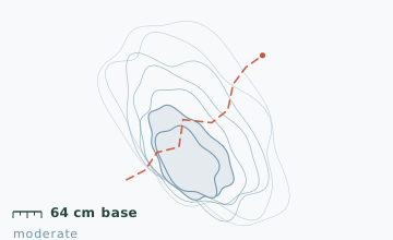
From P13 walk 300 m up the access road and turn right at the winter bypass sign, which is 40 m before the falls base. The bypass climbs through hardwood on a 12-15 degree grade for 1.6 km to the escarpment top, then turns west along the ridge. Nothing on this route is iced in the way the rock steps are.
The line
0.0-1.6 km · Winter bypass climb
A steady climb through sugar maple and red oak on an old logging road. This is the only sustained uphill. Snow depth at the 1.2 km stake measured 64 cm on 21 January.
1.6-3.0 km · Escarpment top and three lookouts
The bypass meets the ridge at 1.6 km. Three lookouts sit at 1.9 km, 2.3 km and 2.8 km, each a 15-30 m spur off the main line to a bare rock edge above the Ottawa River. The third has the best view and a bench.
3.0-5.2 km · Ridge in the woods
A broad, gently rolling ridge line with mature hemlock on the north side. This section is the quietest on the route and the place to see tracks; deer, fisher and the occasional porcupine are all regular.
5.2-6.8 km · Descent to the fields
The ridge drops on a 15-degree grade to an old farm field, then follows a fence line back east to the access road. The last 400 m is on flat field with deep drifts against the fence.
Travelling the line, step by step
- Take the bypass sign 40 m before the falls baseThe sign is small and easy to walk past. If you reach the falls base and see the chain, you have gone too far.
- Walk the three lookout spurs as out-and-backsEach is 15-30 m each way. Leaving your pack at the junction is fine and makes the edges easier to judge.
- Stay 3 m back from any edge with no visible ground beyondCornices on the Eardley escarpment build in February and fail under a person's weight. If you cannot see the ground past the edge, you are standing on snow that is not supported.
- Take the fence line on the final descentThe field below the ridge is deep and uneven; the fence line is the shallowest and firmest line back to the access road.
What to carry
- Snowshoes - the bypass and the ridge are both unpacked on weekdays
- Microspikes as a backup for the descent to the fields, which can glaze
- One or two poles
- Insulated bottle; the three lookouts are windy and the ridge has no shelter
- Warm hat and a windproof layer for the lookout stops
- Binoculars if you want to make sense of the river ice below
What can go wrong
- IceThe final 400 m of field can be glazed where the fence line shades it.
- AvalancheThe three lookout spurs end at an unfenced 60 m rock edge above the highway; this is a fall hazard, not a snow hazard.
The lookouts are the only place on this route where a mistake has serious consequences - all three end at an unmarked edge with a 60 m drop and no barrier. Snow cornices build on the escarpment edge in February and break without warning. Keep 3 m back from any edge where you cannot see the ground beyond it, and put a hand on the person in front at the third lookout, which is the most exposed.
Before you go
- Is this a real alternative to the falls route?
- Yes. It reaches the same escarpment top with no iced rock steps, at the cost of 2.6 km and one extra hour. On any day when the falls steps are glazed, this is the better choice.
- Why are the lookouts unfenced?
- The park leaves the escarpment edge in its natural state and marks the spurs rather than the edge. The benches at the third lookout are the intended stopping point.
- Can I connect the two routes?
- Yes, up by the bypass and down by the falls steps, which avoids descending the iced section but still requires crampons for the descent. It is the option most experienced local parties take.
Nearby and similar
- Luskville Falls Ascent · Gatineau Park · 4.2 km · Challenging
- La Peche Ridge Link · Gatineau Park · 7.2 km · Moderate
- La Peche Lake Circuit · Gatineau Park · 9.4 km · Easy
The figures above are our own measurements from the date shown. Only the conditions on your day count: check the current forecast, the gate bulletin and the snowpack before you set out, and treat every ice crossing as open until you have tested it.