Mountain sector · White Mountains · ·
Lost Pond Trail
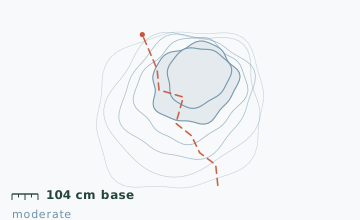
Lost Pond sits in a hollow directly under the Huntington Ravine headwall, which makes it one of the most sheltered spots in the White Mountains and one of the most deceptive. The pond is 3.4 km from a heated building, and the terrain between them includes a 95 m climb over broken rock that has put more people on the rescue list than the distance suggests. Snow depth measured 104 cm at the 1.2 km stake on 27 January, with a 6 cm ice crust from a mid-month rain event buried 30 cm down.
Arrival
Route 16 to Pinkham Notch, 18 km north of Jackson. The lot is plowed continuously and there is a staffed desk from 06:30. The route leaves the west side of the lot on the Old Jackson Road for 700 m before turning south onto the Lost Pond Trail proper. Do not take the east-side summer trailhead, which leads into the Huntington Ravine approach and is not broken out in winter.
The line
0.0-0.7 km · Old Jackson Road
A wide, flat old carriage road that is usually packed by the time you arrive. This is the only easy part of the route. Snowshoes can stay on the pack here.
0.7-1.9 km · Broken rock climb
The route turns south and climbs 95 m over broken rock and root steps. Snow bridges form over the gaps between boulders and they collapse under a snowshoe but usually hold a boot, which is why some parties take snowshoes off for this section.
1.9-2.6 km · Pond shore
The trail reaches the north shore of Lost Pond. The pond is shallow, spring-fed and sits in permanent shade from November to March, so it holds ice later than anything else nearby - mid-April ice is normal.
2.6-3.4 km · Return to the notch
The descent back over the broken rock is slower than the climb. The final 700 m on the carriage road is a straight run back to the lot.
Travelling the line, step by step
- Start from the west side of the lot, behind the trading postThe east trailhead sign points to the Huntington Ravine approach and is not broken in winter. The west entrance is marked with a small winter-route placard.
- Decide at 0.7 km whether to switch to spikesLook at the first 20 m of the rock climb. If it is glazed, microspikes will be faster than snowshoes and the snow bridges will hold you better.
- Stay on the tread over the boulder fieldThe gaps between boulders are bridged by snow that looks continuous. Probe with a pole before weighting anything that has a darker tone.
- Turn around at the pond shoreThe continuation toward Huntington Ravine crosses a runout zone within 400 m. If you have not read the day's avalanche bulletin, that is your turnaround.
What to carry
- Snowshoes with a low-profile binding so you can take them off and put them on quickly on the rock section
- Microspikes as an alternative for the rock climb
- One pole, but a second is useful on the descent
- Insulated bottle inside the pack; nothing here stays liquid in an outer pocket
- Goggles; the notch funnels wind even when the pond itself is calm
- Headlamp - the rock section is slow in the dark and the lot is lit, which makes it a tempting late start
- Avalanche bulletin printout if you plan to continue toward Huntington Ravine (do not, without training and a partner)
What can go wrong
- AvalancheThe north-facing slope above the pond loads heavily and has run to the shore in recorded winters.
- IceA 6 cm rain crust sits 30 cm down in the snowpack from mid-January, which makes the rock section unpredictable underfoot.
- Open waterThe outlet at the north end of the pond stays partly open all winter.
The single most important decision on this route is where to stop. The trail continues past the pond toward Huntington Ravine and that terrain is a different objective entirely: 35-degree slopes, a serious avalanche forecast and two recorded fatalities in the last decade. Lost Pond itself is a reasonable half-day; the ravine is not a snowshoe route. The Visitor Center desk logs parties and can tell you the day's avalanche rating.
Before you go
- Is this route safe without avalanche gear?
- To the pond and back, yes. The route stays below 750 m and does not cross a runout zone on the standard line. Beyond the pond it does, and gear plus training becomes mandatory.
- Why is the pond called Lost Pond?
- It has no outlet stream on the surface for most of the year - water leaves through the ground. Early surveyors mapped it in three different places.
- Can I do this with kids?
- The carriage road section, yes. The broken rock climb at 0.7 km is slow and awkward for short legs, and most families turn around there.
Nearby and similar
- Tuckerman Ravine Base Line · White Mountains · 7.6 km · Challenging
- Bear Notch West Side Road · White Mountains · 11.2 km · Easy
- Luskville Falls Ascent · Gatineau Park · 4.2 km · Challenging
The figures above are our own measurements from the date shown. Only the conditions on your day count: check the current forecast, the gate bulletin and the snowpack before you set out, and treat every ice crossing as open until you have tested it.