Park sector · Algonquin Park · ·
Mizzy Lake Boardwalk Line
Mizzy Lake is the classic Algonquin wildlife route in summer and something quite different in winter, when the nine boardwalk sections become the main event: 1.4 km of planking under 40-70 cm of snow, with a walkable tread only where someone has been before you. It is also the best place in the park to see wolf and otter tracks, because the route strings together four ponds and a bog in a single line.
Arrival
Highway 60 to the Mizzy Lake sign, 25 km east of the West Gate. The gate is open year round and the highway is plowed and sanded. From the trailhead the route climbs 40 m in the first 600 m and then works north-east through a series of ponds. The first boardwalk section starts at 1.9 km and is the one that catches people out, because it is not visible until you are standing at its edge.
The line
0.0-1.9 km · Ridge above the highway
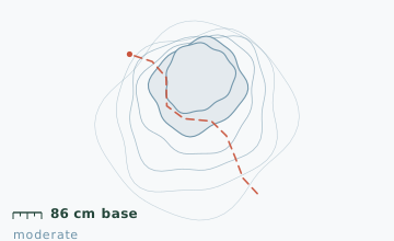
A 40 m climb on a wide old road, then a gentle descent to the first pond. Snow depth at the 1.5 km stake measured 86 cm on 30 January with a 12 cm rain crust at 35 cm depth from a late-January thaw.
1.9-4.4 km · First three boardwalk sections
Three plank sections of 90 m, 140 m and 60 m, each under snow. The tread is only walkable where it has been packed; step off it and you go through into the gap between the planks. Feel for the deck edge with a pole before each step.
4.4-7.0 km · Ponds and the bog
Four ponds in a chain, separated by short woodland links. The bog section at 5.8 km has six more plank runs and is the most delicate part: the ground under it is floating mat and there is no solid alternative line.
7.0-10.8 km · Long return through mixed forest
The route turns south and follows an old logging road back to Highway 60, rejoining the highway 700 m east of the trailhead. Walking the shoulder back is permitted and is shorter than re-entering the woods.
Travelling the line, step by step
- Stop at the first boardwalk edge and probe before stepping onAt 1.9 km the deck starts without warning. Chip down with a pole until you feel the plank, then step on the packed line and keep your feet inside it.
- Keep your snowshoe frame inside the tread widthThe packed line on the planks is usually 35-45 cm wide. A wide snowshoe that overhangs the deck edge will drop into the gap on the next step.
- Cross the pond three to four outlet without stoppingThe plank section there is 1.2 m wide with open water on both sides. Poles in one hand, eyes on the far end, keep moving.
- Return by the logging road, not by re-entering the boardwalkThe return leg on the old logging road is 700 m shorter and has no plank sections at all. Most people who get hurt here do it on a second pass through a boardwalk section in fading light.
What to carry
- Snowshoes with a narrow frame - wide frames catch between the planks
- Two poles; the boardwalk sections need probing every step
- Microspikes as an alternative on the boardwalk if the deck is hard-packed and glazed
- Insulated bottle and food; there is no shelter on the route
- Camera with a strap; the track sightings here are the reason people come
- Ontario Parks winter day-use permit, available at the gate or online
What can go wrong
- IceTwo ponds on the chain have beaver lodges with open water at the entrances all winter.
- Open waterThe outlet between ponds three and four stays open and is crossed by a plank section that is only 1.2 m wide.
- IceA 12 cm rain crust sits 35 cm down in the snowpack from late January, which makes the boardwalk edges unpredictable.
The boardwalk gaps are the only real risk on this route and they are a leg-breaker rather than a life-threatening hazard: step through and you can be wedged to the knee between planks with a 30 cm drop below. Probe every step on plank sections and do not follow another party's track blindly, since their line may be 40 cm off the deck. The park's winter gate staff log parties at the West Gate and expect you to check out by phone if you are late.
Before you go
- Is the boardwalk visible under the snow?
- Barely. In a normal January there is 40-70 cm over the deck and the only cues are the slightly firmer tread where others have walked and the change in sound underfoot.
- Do I need a permit?
- Yes, an Ontario Parks winter day-use permit. It is sold at the West Gate and online, and it covers all Highway 60 corridor trails.
- Why is the route called the wildlife trail?
- It strings together four ponds, a bog and a beaver meadow, which is the highest concentration of edge habitat along the corridor. Wolf, otter, marten and moose tracks all show up on the ponds in winter.
Nearby and similar
- Track and Tower Trail Line · Algonquin Park · 7.7 km · Challenging
- Moose Bog Access Road · Algonquin Park · 9.6 km · Easy
- St. Regis Portage Line · Adirondack High Peaks · 10.6 km · Moderate
The figures above are our own measurements from the date shown. Only the conditions on your day count: check the current forecast, the gate bulletin and the snowpack before you set out, and treat every ice crossing as open until you have tested it.